
Extreme Temperature
It is not uncommon to experience drastic environmental temperature changes in New England. The hottest temperature ever recorded in Connecticut was 106°F (1995). The coldest temperature ever recorded in Connecticut was -37°F (1943). Extreme conditions may last multiple days and sometimes pose life-threatening situations.
BEFORE EXTREME COLD CONDITIONS OCCUR
- Ensure you are signed up for UConnALERT.
- Listen to local weather forecasts and stay aware of upcoming temperature changes.
- Know where you can go on campus to stay out of the cold, such as the library and the Student Union.
- Download the FEMA App to receive weather alerts from the National Weather Service (NWS).
- Ensure your animals have plenty of food/water and are not exposed to excessive cold temperatures.
- Know the signs of frostbite and hypothermia.
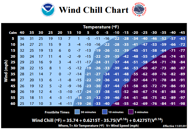
Frostnip is a mild version of frostbite, where there is no tissue destruction. The skin may appear red and one may feel numb in the area where it feels cold.Occurs when the skin and body tissue just beneath it freezes. Loss of feeling and white or pale appearance in extremities, such as fingers, toes, earlobes, face and the tip of the nose. Call 911 if you experience this condition.Dangerously low body temperature. Uncontrollable shivering, memory loss, disorientation, incoherence, slurred speech, drowsiness and apparent exhaustion. Call 911 if you experience this condition.
These can be life-threatening conditions. Call 911 if you experience a cold-weather emergency.
- Familiarize yourself with these terms to help identify an extreme cold hazard:
Prepare Your Car
- Check your tire pressure. Drastic temperature changes can alter your tire pressure.
- Ensure your fuel tank is at least half full (so you can stay warm if stranded).
- Keep jumper cables in your vehicle.
- Keep an ice scraper to clear your windshield.
- Consider keeping blankets/warm clothes stored in your car during winter months.
- Keep a car charger for your cell phone in your vehicle.
Note: If you become stranded in your vehicle during a winter storm, ensure that your tailpipe is unobstructed. A blocked tailpipe can cause you vehicle to lethally fill with carbon monoxide.
Check out this Ready.gov Preparedness Video:
DURING EXTREME COLD CONDITIONS
Protect yourself from extreme cold. If you experience extreme cold weather conditions:
- Stay indoors as much as possible. Only go outside if necessary.
- If you are outside, keep dry and avoid overexertion.
- Watch for signs of frostbite or hypothermia. If you think you're experiencing symptoms, call 911 immediately.
- Dress for the weather
- If you must go outside, wear several layers of loose-fitting, lightweight, warm clothing rather than one layer of heavy clothing. The outer garments should be tightly woven.
- Cover your hands. Mittens are warmer than gloves.
- Wear a hat to prevent loss of body heat.
- Cover your mouth with a scarf to protect your lungs.
- Try not to leave any skin exposed while outside.
- Before tackling strenuous tasks in cold temperatures, consider your physical condition, the weather factors and the nature of the task.
- Do not leave windows open or prop exterior doors (this may increase the likelihood of frozen pipes).
AFTER EXTREME COLD CONDITIONS SUBSIDE
These conditions can last for days or reoccur frequently. Therefore, continue to monitor media for local weather conditions. Remember to follow the instructions of emergency personnel and University officials during an emergency. You should consider your personal safety in every unique situation. There are exceptions to all guidance and prescribed directions, so use common sense.
To view our sources and for more information on extreme cold, visit the following websites:
http://www.nws.noaa.gov/om/cold/
http://www.nws.noaa.gov/om/cold/resources/wind-chill-brochure.pdf
https://www.ready.gov/winter-weather
http://ksi.uconn.edu/
BEFORE EXTREME HEAT CONDITIONS OCCUR
- Ensure you are signed up for UConnALERT.
- Listen to local weather forecasts and stay aware of upcoming temperature changes.
- Know where you can go on campus to stay out of the heat, such as the library or Student Union.
- Download the FEMA App to receive weather alerts from the National Weather Service (NWS).
- Check out these tips to Beat the Heat from the Centers for Disease Control.
- Consider those in your community who are older, very young, sick or overweight. They are more likely to become victims of excessive heat and may need help.
- Learn how to recognize and treat heat-related emergencies. The conditions below can quickly become life threatening - always call 911 if you experience a heat-related emergency.
- Heat Cramps: Muscular pains and spasms due to heavy exertion. Although heat cramps may be less severe, they are often the initial signs that the body is having trouble with the heat.
- Heat Exhaustion: May occur when people are very active in a hot, humid place where body fluids are lost through heavy sweating. During physical activity, blood flow to the skin is increased, causing blood flow to the vital organs to decrease to and resulting in a form of mild shock. If not treated, the victim's condition will worsen. Body temperature will keep rising and the victim may suffer heat stroke.
- Heat Stroke: A life-threatening condition. The victim's temperature control system, which produces sweating to cool the body, stops working. The body temperature can rise so high that brain and organ damages may result in death if the body is not cooled quickly.
- Sun Stroke: Can be used interchangeably with heat stroke.
- Dehydration: During times of extreme heat, the body loses fluids through sweat and you can become dehydrated during times of extreme heat. Symptoms include dry mouth, extreme thirst, dry skin and mucus membranes, little or no urination, darker urine and sunken eyes.
- Familiarize yourself with these terms to help recognize an extreme heat hazard:
15 degrees. The NWS provides a Heat Index Chart.
DURING EXTREME HEAT CONDITIONS
If you experience extreme heat weather conditions:
- Drink plenty of water while avoiding alcohol and excess amounts of caffeinated drinks.
- Eat well-balanced and light meals.
- Stay in air conditioned rooms as much as possible.
- Limit exposure to the sun.
- Cancel or do not participate in outdoor activities.
- Closely follow local weather forecasts.
- Dress in loose fitting, light colored clothing. Dark colors absorb the sun's rays.
- Use sunscreen.
- Call 911 if you suspect a medical issue.
Remember, dehydration is preventable!
Inside Your Vehicle
According to the National Weather Service, 39 children died in the United States in 2016 from vehicular heatstroke. Direct sunlight on a hot day can rapidly increase the internal temperature of your vehicle. Never leave children or pets in a potentially hot vehicle. According to the National Weather Service, "a dark dashboard or seat can easily reach temperatures in the range of 180 to over 200°F."

Visit the National Weather Service website for more information and to watch the animation shown above, which demonstrates how quickly internal temperatures can become dangerous.
Fire Danger
According to the CT Department of Energy and Environmental Protection, "Connecticut traditionally experiences high forest fire danger in the spring from mid-March through May." Never burn without checking the daily fire danger report and obtaining necessary permits.
AFTER EXTREME HEAT CONDITIONS SUBSIDE
These conditions can last for days or reoccur frequently. Therefore, continue to monitor media for local weather conditions. Remember to follow the instructions of emergency personnel and University officials. You should consider your personal safety in every unique situation. There are exceptions to all guidance and prescribed directions, so use common sense.
To view our sources and for more information on extreme heat, visit the following websites:
https://www.ready.gov/heat
https://www.cdc.gov/disasters/extremeheat/index.html
http://www.nws.noaa.gov/om/heat/index.shtml
http://ksi.uconn.edu/